
Land management is a critical part of mining, infrastructure development, and large-scale industrial projects. Managing land boundaries, ownership information, property records, and acquisition activities often involves multiple departments, field teams, and extensive documentation.
When this information is maintained across physical files, spreadsheets, and disconnected systems, tracking changes and monitoring progress becomes challenging.
A Land Record Management System (LRMS) provides a more structured approach by bringing land records, geospatial information, and field activities together on a single digital platform.
At Polygon Geospatial, we use GIS technology and digital workflows to help organisations manage land information more efficiently and make informed decisions throughout the project lifecycle.
What Is a Land Record Management System (LRMS)?
A Land Record Management System is a GIS-enabled digital platform designed to organise, manage, update, and monitor land-related information.
It connects geographical land boundaries with associated records, including ownership details, property information, acquisition status, and supporting documents.
Unlike conventional record management methods, a GIS-based LRMS allows users to visualise land parcels directly on interactive maps.
This combination of spatial information and digital records helps project teams understand not only what information is available about a parcel, but also where that parcel is located and how its status changes over time.
Why Is LRMS Important for Mining Projects?
Mining projects frequently involve extensive land areas, multiple landowners, different property categories, and complex land acquisition processes.
Accurate, accessible land information is essential for planning operations, verifying property details, coordinating field surveys, and monitoring acquisition progress.
Without a centralised system, teams may encounter difficulties in identifying land parcels, accessing updated records, tracking field verification, and maintaining consistent documentation.
A GIS-based LRMS helps address these challenges by connecting field-level observations with office-level monitoring and decision-making.
It provides a clearer picture of the land acquisition process and improves coordination between surveyors, land acquisition officers, project managers, and administrative teams.
Key Capabilities of Polygon Geospatial's LRMS
1. GIS-Based Land Parcel Mapping
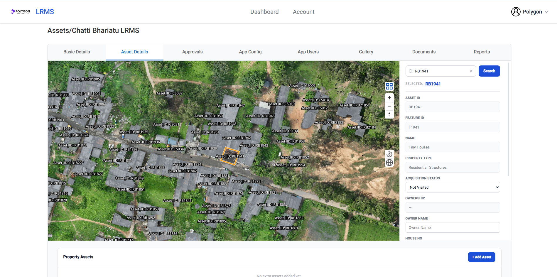
LRMS integrates land records with interactive GIS maps, enabling users to view individual land parcels, asset locations, and associated information.
Satellite imagery, drone orthomosaics, and other geospatial datasets can provide additional geographic context for identifying properties and understanding site conditions.
2. Centralised Digital Land Records
The system organises essential information such as parcel identifiers, landowner details, property categories, acquisition status, and supporting records.
Maintaining these details within a common digital environment reduces dependence on scattered files and makes information easier to retrieve and review.
3. Mobile Field Data Collection
Field verification is an important part of land management.
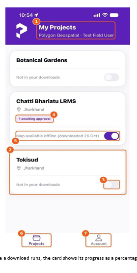
Polygon Field, the mobile application supporting LRMS workflows, enables authorised surveyors to access assigned projects, inspect mapped assets, update property information, and attach photographs or documents directly from the site.
The application also supports offline fieldwork, allowing surveyors to record information in areas with limited mobile connectivity and synchronise changes when a connection becomes available.
4. Workflow Management and Approvals
Information collected in the field often requires verification before becoming part of the official project record.
LRMS supports an approval process through which administrative teams can review, approve, or reject field-submitted changes.
This helps maintain data consistency while providing greater accountability across the project.
5. Document Management and Audit Trails
Land management involves numerous supporting documents, photographs, survey records, and administrative approvals.
LRMS provides a central location for organising project-related documents and field media.
Audit trails also help administrators track recorded changes and review the history of project activities.
6. Progress Monitoring and Reporting
Project managers need an accurate understanding of land acquisition progress.
LRMS enables teams to review property records, monitor acquisition status, and generate reports in formats such as PDF and CSV.
These reporting capabilities support project reviews, management meetings, and administrative decision-making.
Connecting Field Operations with Administrative Control
One of the important advantages of Polygon Geospatial's LRMS is the connection between field survey activities and centralised administration.
Field teams can verify parcel information, capture supporting evidence, and submit updates through the mobile application.
Administrative teams can then review those submissions using the web portal, monitor project records, and maintain oversight of the information collected.
This connected workflow reduces unnecessary information handovers and helps ensure that office decisions are based on updated field observations.
Benefits of Digital Land Record Management
Adopting a GIS-enabled LRMS can bring several operational advantages to land-intensive projects.
Improved data accessibility: Teams can locate relevant property information and supporting documents more efficiently.
Better visibility: Interactive maps provide geographic context for understanding land parcels and project boundaries.
Reduced manual work: Digital field collection and structured approvals minimise repeated data entry and paperwork.
Greater transparency: Recorded updates and audit trails make it easier to review how land information has changed.
Improved project coordination: Surveyors, administrative teams, and decision-makers can work within a connected information environment.
Informed planning: Access to mapped property information and acquisition progress supports better project-level decisions.
Building a More Connected Approach to Land Management
As mining and infrastructure projects become increasingly data-driven, land information needs to be accurate, accessible, and connected to real-world locations.
Digital land management is not simply about converting paper records into electronic files. It is about creating a reliable system in which spatial information, field verification, documentation, and administrative workflows work together.
By combining GIS mapping, remote sensing, digital land records, mobile data collection, and workflow management, organisations can improve the way they manage land-related activities.
Polygon Geospatial: Bringing Intelligence to Land Management
Polygon Geospatial develops geospatial platforms that integrate surveying, GIS, remote sensing, and enterprise applications to address real-world operational challenges.
Our LRMS capabilities support organisations in managing land information, monitoring field updates, and maintaining visibility over land acquisition activities.
Whether the requirement involves mining land records, property asset mapping, or digital land management workflows, our approach brings geospatial intelligence into everyday project operations.
Looking to modernise your land management processes?
Discover how Polygon Geospatial's GIS-enabled land management solutions can support your projects.
Visit: https://polygongeo.com
Explore our digital land acquisition platform: https://polygongeo.com/products/landacquire
- GIS
- Land Management
- LRMS
- Mining Land Acquisition
- Digital Land Records
- GIS Parcel Mapping
- Mobile Field Data Collection
- Land Acquisition Workflows
- Property Asset Mapping
- Land Ownership Verification
- Offline Field Surveys
- Land Acquisition Approvals
- Acquisition Progress Tracking
- GIS Audit Trails