Innovative Approaches to Waste Quantification Using Drone Technology
Waste management is a critical component of environmental sustainability and urban planning. Traditional methods of waste quantification often involve manual surveys, which can be time-consuming, labor-intensive, and sometimes hazardous. Enter drone technology – a game-changer in the field of waste management. By leveraging advanced drone technology, we can achieve more accurate, efficient, and safer waste quantification. This blog explores innovative approaches to waste quantification using drones and how they are transforming the industry.
The Challenges of Traditional Waste Quantification
Traditional methods of waste quantification typically involve
manual measurements and visual inspections. These methods come with several
challenges:
Time-Consuming: Manual surveys can take a significant amount of
time, especially for large waste sites.
Labor-Intensive: These methods require considerable human effort,
which can be both costly and resource-intensive.
Safety Risks: Surveying large and hazardous waste sites poses
safety risks to workers.
Accuracy Issues: Manual measurements are prone to human error,
leading to inaccurate data.
How Drones are Transforming Waste Quantification
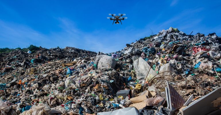
Drones offer a revolutionary solution to these challenges.
Equipped with high-resolution cameras and advanced sensors, drones can quickly and
accurately capture detailed data from waste sites. Here are some innovative
approaches to waste quantification using drone technology:
1. Aerial Imaging and Photogrammetry: Drones can capture
high-resolution aerial images of waste sites. These images are processed using
photogrammetry software to create detailed 3D models and orthomosaic maps. This
approach provides precise measurements of waste volume and distribution.
2. LiDAR Technology: Light Detection and Ranging (LiDAR) technology
mounted on drones can create highly accurate 3D models of waste sites. LiDAR uses
laser pulses to measure distances and generate detailed topographic maps, even in
challenging environments with dense vegetation or rough terrain.
3. Thermal Imaging: Thermal cameras on drones can detect
temperature variations within waste sites. This is particularly useful for
identifying areas of active decomposition, which generate heat. Thermal imaging
helps in assessing the activity levels and potential risks associated with waste
sites.
4. Multispectral and Hyperspectral Imaging: Drones equipped with
multispectral and hyperspectral sensors can capture data across different
wavelengths of light. This technology helps in identifying different types of waste
materials based on their spectral signatures, enabling more accurate classification
and quantification of waste.
5. Automated Data Processing and Analysis: Advanced software
solutions can automate the processing and analysis of data captured by drones.
Machine learning algorithms and AI-driven tools can quickly process large datasets,
providing real-time insights and generating detailed reports on waste
quantification.
"Drones are not just changing the way we manage waste; they are providing us with the tools to create a cleaner, safer, and more sustainable world."
Benefits of Using Drones for Waste Quantification
Drone mapping can be applied to various stages of a construction
project, including:
Efficiency: Drones can cover large areas quickly, significantly
reducing the time required for waste quantification.
Cost-Effectiveness: By reducing the need for manual labor and
equipment, drones can lower the overall costs of waste surveys.
Accuracy: High-resolution imaging and advanced sensors ensure
precise and reliable data.
Safety: Drones eliminate the need for workers to enter hazardous
waste sites, reducing safety risks.
Comprehensive Data: Drones provide detailed and comprehensive data,
enabling better decision-making and planning.
Real-World Applications
Several organizations and municipalities are already leveraging
drone technology for waste quantification. For example:
Municipal Waste Management: Cities are using drones to monitor and
manage landfill sites, ensuring efficient waste disposal and minimizing
environmental impact.
Industrial Waste Sites: Companies are deploying drones to quantify
waste generated from industrial processes, helping them comply with environmental
regulations and optimize waste management strategies.
Environmental Research: Researchers use drones to study waste
accumulation in natural habitats, such as oceans and forests, providing valuable
data for environmental conservation efforts.
Conclusion
Drone technology is revolutionizing waste quantification by providing innovative, efficient, and accurate solutions. As the technology continues to advance, we can expect even more sophisticated approaches to waste management, ultimately contributing to a more sustainable and environmentally-friendly future.
By embracing these innovative approaches, organizations and municipalities can enhance their waste management practices, improve efficiency, and contribute to a healthier environment. The future of waste quantification is here, and it's flying high with drone technology!